Public comment sought for Franklin County Bike Plan update
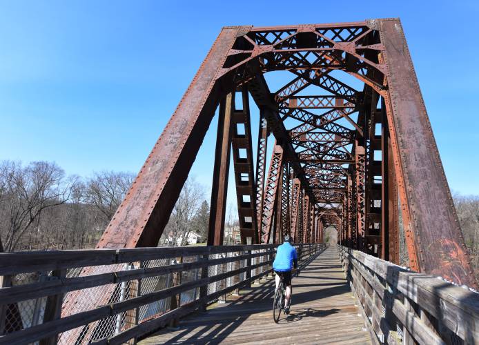
A lone bicyclist crosses the Connecticut River from Deerfield into Montague in 2020. The Franklin Regional Council of Governments is asking the public to complete an online survey with an interactive mapping component to provide information for an updated Franklin County Bike Plan. STAFF FILE PHOTO/PAUL FRANZ
| Published: 03-05-2024 3:59 PM |
GREENFIELD — The Franklin Regional Council of Governments (FRCOG) is asking the public to complete an online survey with an interactive mapping component to provide information for a new Franklin County Bike Plan.
By updating the bike plan for the first time in 15 years, the goal is to advance the existing bicycle infrastructure to facilitate easier biking for all, according to FRCOG Transportation Program Manager Beth Giannini. The intention is to plan a transportation system that promotes biking as a viable mode of transportation, diversifies the transportation network, encourages physical activity and reduces greenhouse gas emissions.
The 2024 update to the Franklin County Bike Plan will identify areas of existing cycling networks that need improvement while considering the needs of commuters, students, store patrons, outdoor enthusiasts and visitors. It will also recommend steps to create a bicycle-friendly region based on feedback from Franklin County residents.
To inform the work, FRCOG has developed an online survey and interactive map for residents to indicate areas for improvement, preferred bike routes, amenities and issue spots. Residents can upload pictures and provide further details for each point.
The interactive map can be accessed at tinyurl.com/Input-Map and the survey can be accessed at tinyurl.com/Survey-Bike. Both will be available until April 1. For more information on bicycle planning in the region, visit frcog.org/project/franklin-county-bikeway.
The plan is set to be completed by the end of September, with a public comment period scheduled for August.
The county’s first bike plan was established in 1993, with one of the main projects being the creation of the Franklin County Bikeway. This network consists of off-road and shared-road bike routes, with well-known off-road bikeways such as the Riverside Greenway in Greenfield and the Canalside Rail Trail in Montague and Deerfield completed about 15 years ago.
Following the completion of these off-road paths, FRCOG shifted focus to a shared roadway plan, with many roadways now designated with signs added in the past decade.
Article continues after...
Yesterday's Most Read Articles
 Serious barn fire averted due to quick response in Shelburne
 Bridge of Flowers in Shelburne Falls to open on plant sale day, May 11
 Political newcomer defeats Shores Ness for Deerfield Selectboard seat
 Roundup: Pioneer baseball wins Suburban League West title following 2-0 win over Hopkins
 As I See It: Between Israel and Palestine: Which side should we be on, and why?
 Employee pay, real estate top Erving Town Meeting warrant
Bicycle infrastructure planning has evolved to adopt a holistic approach, focusing on accommodating bicycles and pedestrians on streets rather than planning separate routes for different vehicles, according to Giannini.
“We aim to address all aspects of bike riding in this plan, including the interface between transit and biking, which was not covered in the last plan,” Giannini said.
This change is evident locally in state-led projects, such as separated bike lanes on Routes 5 and 10 in Deerfield, state roads in Northfield, and Wisdom Way and River Street in Greenfield.
Additionally, FRCOG has identified off-road paths for consideration in the new plan, including bike paths connecting Orange and Athol, an alternative to the section of Route 2 in Erving through Wendell, and a path linking the southern part of Franklin County to the University of Massachusetts Amherst.
“There’s been a shift in transportation planning,” Giannini said, “and we believe it’s the right time as regional planners to take a fresh look.”
Bella Levavi can be reached at blevavi@recorder.com.

 No surprises in Wendell election
 New Salem election ushers in new Selectboard member
