Ominous ocean warmth points to an active Atlantic hurricane season ahead

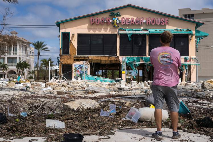
Doc’s Beach House in Bonita Springs, Florida, set right on the beach, was destroyed during Hurricane Ian. PHOTO BY THOMAS SIMONETTI FOR THE WASHINGTON POST
| Published: 02-19-2024 7:01 AM |
Hurricane season is still more than three months away, but in parts of the tropical Atlantic, it feels like we might as well already be in the thick of it. Across a strip of ocean where many cyclones are born, February ocean temperatures are closer to what scientists expect in July.
The ominous warmth is stirring concerns of yet another hyperactive Atlantic hurricane season. Seven of the last eight seasons have been above normal.
Last year, similarly unusual warmth fueled a storm season that was significantly more active than meteorologists might have expected given the presence of the El Niño climate pattern, which emerged last spring and creates conditions that tend to inhibit Atlantic cyclone formation.
As meteorologists look ahead to this hurricane season, which begins June 1, they see an increasing likelihood that a La Niña pattern will replace El Niño by late summer or early fall. That is another bad sign for the U.S. coastline — La Niña is associated with active patterns in the tropical Atlantic.
It’s still too early to say whether the warmth will persist into hurricane season, or when La Niña might arrive. But, especially together, the trends suggest that an active season could be difficult to avoid, said Michael Lowry, a meteorologist with WPLG-TV in Miami and a former National Hurricane Center scientist.
“There’s plenty of time ahead before we get to the meatiest part of the hurricane season,” Lowry said. “But a lot’s going to have to change … for forecasters to feel much more comfortable going into hurricane season.”
Last spring, the strongest climate signal scientists know of — El Niño — gave every indication of a slowdown in Atlantic hurricane activity in the summer and fall.
El Niño’s signature is a surge of warm waters and towering clouds in the central and eastern Pacific. It triggers changes in atmospheric circulation that, on the other side of the planet, can make it harder for tropical storms to form and strengthen: Areas of high pressure with sinking air are more common over the Atlantic, and wind shear, when wind speed and direction vary at different altitudes, increases.
Article continues after...
Yesterday's Most Read Articles
 Retired police officer, veteran opens firearms training academy in Millers Falls
 UMass graduation speaker Colson Whitehead pulls out over quashed campus protest
 As I See It: Between Israel and Palestine: Which side should we be on, and why?
 Real Estate Transactions: May 10, 2024
 Baseball: Caleb Thomas pitches Greenfield to first win over Frontier since 2019 (PHOTOS)
 High Schools: Greenfield softball squeaks out 1-0 win over Franklin Tech in pitchers duel between Paulin, Gilbert
The expectation of El Niño prompted National Oceanic and Atmospheric Administration forecasters to predict a mostly typical Atlantic hurricane season, a downgrade from years of increased storm activity.
But as El Niño developed, and unusual warmth appeared well beyond the Pacific zones the climate pattern is known for, forecasters warned that a quieter season was far less than certain.
By August, it became clearer: The ocean warmth was likely to counteract El Niño’s typical effect in the Atlantic, and NOAA upgraded its forecast. The season ended up with about 20% more activity than average, as measured by a statistic known as accumulated cyclone energy.
Now, with a new tropical weather season ahead, Atlantic temperatures are perhaps even more remarkable.
In a zone of the Atlantic known as the main development region for hurricanes, sea surface temperatures are running well above normal — and 1.1 degree Fahrenheit higher than in any other year on record, said Philip Klotzbach, a tropical meteorologist at Colorado State University.
If that trend persists into hurricane season this summer, it could mean a ripe environment for tropical waves flowing from Africa to develop into cyclones.
“Basically, it is the perfect recipe for hurricanes to form and strengthen,” Alejandro Jaramillo, a meteorologist at the National Autonomous University of Mexico, said in an email.

 Montague Notebook: May 10, 2024
 Deerfield’s Tilton Library expansion ‘takes a village’
 UMass student group declares no confidence in chancellor
