
 My Turn: Let’s leave miracle of trees well enough alone
 County cleanups on tap for Earth Day
 New national campaign targets online exploitation of children
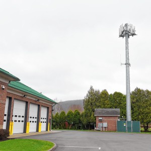 AT&T’s proposed cell tower extension moving forward in South Deerfield
 With new library comes new venue for annual Poet’s Seat Poetry Contest

Fire scorches garage on Homestead Avenue in Greenfield
GREENFIELD — No one was injured after a garage at 42 Homestead Ave. caught fire Wednesday afternoon.Firefighters could be seen hosing down the detached garage at approximately 1 p.m. as smoke poured out of it. According to Fire Chief Robert Strahan,...
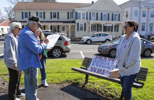
Deerfield residents petitioning to fix ‘dangerous’ intersection
DEERFIELD — With 12 crashes between 2021 and 2023 and likely an even greater number of close calls at the intersection of Routes 5 and 10, North Main Street and Mill Village Road, two residents have launched a petition asking the state Department of...
Most Read
 Orange man gets 12 to 14 years for child rape
 Cleary Jewelers plans to retain shop at former Wilson’s building until 2029
 Greenfield Police Logs: April 2 to April 8, 2024
 Fire scorches garage on Homestead Avenue in Greenfield
 One Greenfield home invasion defendant up for bail, other three held
 Two local school advocates tapped to lead state’s new Small and Rural Schools Committee
Editors Picks
 Montague, Gill and Erving Notebook: April 18, 2024
 PHOTO: Double eagle
 South County Notebook: April 18, 2024
 West County Notebook: April 18, 2024
Sports

High schools: Frontier girls tennis picks up 5-0 win over Turners (PHOTOS)
Make it two Tri-County North League wins to open the season for the Frontier girls tennis team. After knocking off Greenfield in their league opener, the Redhawks followed it up with a 5-0 victory over Turners Falls on Wednesday in South...
 Florence’s Gabby Thomas gearing up for 2024 Paris Olympics
 High Schools: Two-run first inning propels Pioneer baseball past Turners
 Softball: Hannah Gilbert allows two hits as Franklin Tech knocks off Blackstone Valley, 7-3 (PHOTOS)
 UMass basketball: Matt Cross reportedly enters transfer portal
Opinion

Columnist Johanna Neumann: Reaping the rewards of rooftop solar
This week my boys and I are visiting my mom and stepdad for April break. Shortly after we arrived, they proudly gave us a tour of their new PV solar array, which they had installed on the south face of their home earlier this year. My stepdad, Rick,...
 Ben Tobin: Another educational song and dance
 Pushback: Tax fund option helps keep elders in homes
 Maggie Baumer: Access to prosthetics and orthotics for physical activity a right, not a privilege
 Pat Hynes: Nuclear weapons bills need action

Business

Cleary Jewelers plans to retain shop at former Wilson’s building until 2029
GREENFIELD — More than a year after she was told her business would need to vacate its storefront in the former Wilson’s Department Store, Cleary Jewelers owner Kerry Semaski said she plans to keep her shop at its current location until July 2029...
 Tea Guys of Whately owes $2M for breach of contract, judge rules
 Primo Restaurant & Pizzeria in South Deerfield under new ownership
 Patrons can ‘walk down memory lane’ at Sweet Phoenix’s new Greenfield location
 Post-pandemic hardship prompts Between The Uprights closure in Turners Falls
e-Edition
Arts & Life

Sounds Local: Spring is singer-songwriter season: A host of local performers celebrate new work
We are fortunate to live in an area where we can experience all types of music, and when it comes to singer-songwriters, we are fortunate to have so many talented ones living among us. Any given weekend, you can head out to one of the local breweries...
 Crunch time for matzo: An easy-to-make sweet treat that’s Passover Seder-friendly
 Spotlight on women in classical music: Brick Church Music Series’s season comes to a close, April 28-29, with Champlain Trio
 Ready for their close-up: Pothole Pictures announces a season of curated film screenings, live music and $1 popcorn
 You’re up next: Western Mass open mic scene heats up post-pandemic
Obituaries
 Mary Lou Barton
Leyden, MA - Mary Lou (Johnson) Barton, 74, of Leyden MA, took the Lord's hand on April 16, 2024, surrounded by her loving family at home. She was born in Brattleboro, VT on September 7, 19... remainder of obit for Mary Lou Barton
 Judith M. Lively
Greenfield, MA - Judith Mae (Phillips) Lively, 85, of Wells St., passed away on Tuesday April 9, 2024. Judy was born in Greenfield on June 5, 1938 the daughter of Walter and Mildred (Ch... remainder of obit for Judith M. Lively
M. Arlene Andognini
Rowe, MA - M. Arlene (Sibley) Andognini, age 88, of Rowe, Massachusetts, passed away peacefully at Baystate Medical Center, Springfield, Sunday, April 14, 2024. Born at her grandparents hom... remainder of obit for M. Arlene Andognini
Doris M. Taylor
Greenfield, MA - Doris M. Taylor, 98, formerly of Greenfield, passed peacefully at Linda Manor Assisted Living Facility. She was born in Maynard, MA the daughter of William Charles Newman ... remainder of obit for Doris M. Taylor